HandbookModelling
Transport distances
A transport leg is booked in tonne-kilometres, and the kilometres are the half nobody has at hand. The Distances sheet looks them up for road, sea, air and rail, so you can copy the figure straight into an amount or a parameter.
Before you start: a key of your own#
Needs an API key Distances use online services, under your own account. PrismLCA has no key of its own and no server in between. You need the key of the geocoder you pick, and for road distances the openrouteservice key:
| Service | What it does | Cost |
|---|---|---|
| openrouteservice (HeiGIT, Heidelberg) | Routes road distances for a heavy goods vehicle and turns place names into coordinates (geocoding). Road distances always come from here. | Free plan with daily limits; research and non-profit organisations can apply for a larger free plan. |
| Mapbox (USA) | Geocoding only — better with street addresses outside Europe and North America. Not yet tested with the current version. | Paid from the first request; needs a payment method on your Mapbox account. |
Create the key#
Sign up at openrouteservice (account.heigit.org) and create an API key. For Mapbox, create an access token in your Mapbox account.
Enter it in PrismLCA#
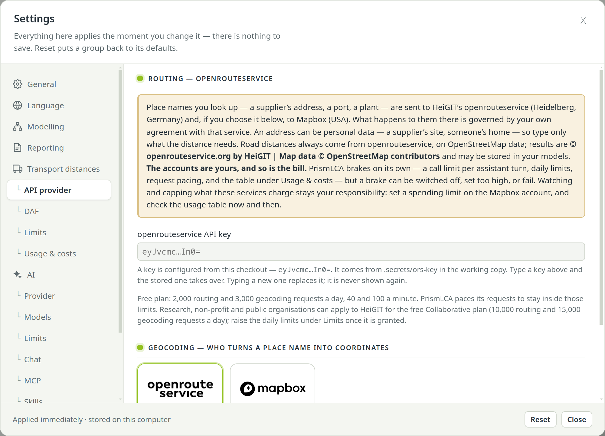
Open SettingsTransport distancesAPI provider and paste the key into openrouteservice API key. PrismLCA keeps it encrypted in your system's credential store (Windows DPAPI or the Linux desktop keyring) and never shows it again.
Choose who geocodes#
Under Geocoding — who turns a place name into coordinates, pick openrouteservice (free) or Mapbox. If you pick Mapbox, paste your Mapbox access token below. Only the service you pick is asked: without its key, lookups stay off rather than going to the other one.
Look up a distance#
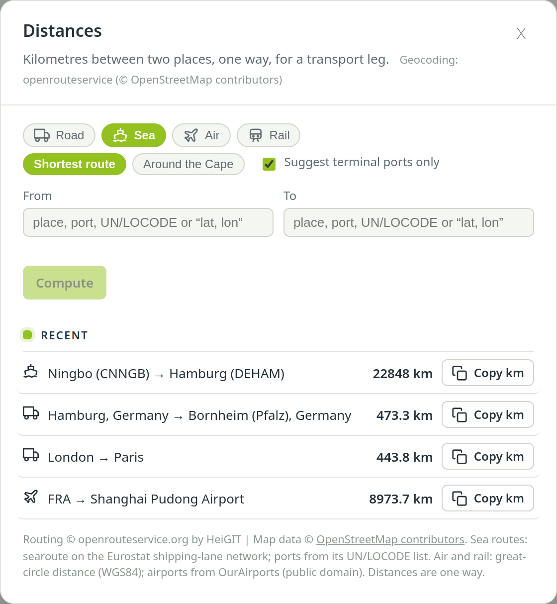
Choose Distances in the toolbar of the Model, Parameters or Scenarios page.
Pick the mode#
Road, Sea, Air or Rail. Road needs the openrouteservice key; with only a Mapbox token it stays greyed out.
Type the two places#
Fill in From and To: a place name, an address, or coordinates as
lat, lon. In sea mode you can also type a port or its UN/LOCODE (DEHAM), in air mode an airport or its IATA code (FRA). Suggestions appear as you type: in sea and air mode from built-in port and airport lists, without any request; in road and rail mode from openrouteservice, if it is your geocoder.Choose Compute#
The sheet shows one row per leg, one way, each with its kilometres — in sea and air mode the road to the terminal, the voyage or flight, and the road onwards. Under a row stands only what changes its figure, such as a ferry that is not included. How these figures were made opens the adjustments and how each figure was measured. The resolved place appears under each field, so you can check that “Bornheim” is the Bornheim you meant.
Copy the figure#
Copy km beside a leg puts its kilometres on the clipboard. Paste them into an exchange amount or a parameter on the page underneath.
The last five lookups stay listed under Recent, each with its own copy button. Click one to put its places and mode back into the fields. They survive a restart.
What each mode measures#
- Road
- Routed for a heavy goods vehicle on OpenStreetMap data. Every route is checked for ferries and vehicle shuttle trains (such as the Channel Tunnel). Such a crossing is taken out of the road figure and shown separately, so you can enter it as its own sea or rail leg.
- Sea
- Sailed along the shipping-lane network, port to port, naming the passages (Suez, Panama, the Cape). Shortest route takes the shortest way; Around the Cape avoids Suez and Panama, as much Asia–Europe traffic has done since late 2023. Which one your study assumes is a decision worth recording. Suggest terminal ports only limits the suggestions to large ports.
- Air
- The great-circle distance between two airports. A trip with a stopover is two legs.
- Rail
- The great-circle distance times a circuity factor. It says nothing about whether a railway exists on that relation — every rail answer repeats that sentence.
In sea and air mode, the road from your place to the port or airport, and from the arrival terminal onwards, is shown as separate road legs, each with its own kilometres and copy button. Enter each as its own road transport. Unless you name a terminal, PrismLCA takes the nearest major one by straight line and says which — for an inland place that is a first guess (freight from Munich usually sails from Hamburg, not Venice), so type the terminal you mean.
Distance adjustment factors (DAF)#
A router or a globe returns the shortest possible distance. Real trucks, ships and planes travel further: detours, approach paths, routes that follow traffic rather than geometry. The GLEC Framework and ISO 14083, the standards for transport emissions, say how much to add. These additions are the distance adjustment factors. PrismLCA applies them by default, and every answer shows the raw figure beside the adjusted one.
| Mode | Default adjustment | In plain words |
|---|---|---|
| Road | × 1.05 (+5 %) | Real road trips run a little longer than the routed one. |
| Air | + 95 km per leg | Take-off, landing and holding patterns, added once per flight. |
| Sea | × 1.15 (+15 %) | Real container routes run about 15 % longer than the shortest lane. |
| Rail | × 1.2 (circuity factor) | Rail lines wind; European freight corridors run at roughly 1.1 to 1.35 times the straight line. |
Road, air and sea follow GLEC. For rail there is no GLEC or ISO factor; the default of 1.2 comes from measured European freight corridors, and you can set your own value between 1.0 and 3.0.
Each can be switched off, and the rail factor changed, under SettingsTransport distancesDAF. The same page switches the separate access legs on or off (Air and sea: deliver the road to and from the airport or port as separate legs, on by default).
Limits and costs#
SettingsTransport distancesLimits sets how much may be spent:
- Offer the distances tool to the assistant — off means the assistant is not even told the tool exists.
- API calls per assistant turn — one pair of places costs up to three calls (two geocodes and a route).
- Geocoding calls per day and Routing calls per day — shared by the assistant and the Distances button. The defaults match the openrouteservice free plan; 0 means no limit.
SettingsTransport distancesUsage & costs shows the calls of today and this month and what they cost, per provider.
Let the assistant look it up#
The assistant has the same distances tool and uses the same service, so its figures and yours cannot disagree. It names the terminal it assumed, picks the usual gateway when the nearest airport is a poor fit, and asks you when several ports are about equally plausible. You can switch the tool off for one conversation with Distances in the chat's + menu.
Add the transport of the hose reel from the factory in Ningbo, China, to a warehouse in Duisburg, Germany: by sea to Rotterdam, then by lorry. Look up the distances and show me the legs.
What leaves your computer#
The place names and addresses you type — in the sheet, in its suggestions, or through the assistant — are sent to the geocoder you picked — openrouteservice or Mapbox — and the coordinates found go to openrouteservice for road routes. An address can be personal data, such as a supplier's site or someone's home, so type only what the distance needs. Without a key nothing is sent at all. The full list is in What leaves your computer.